
Discover 23 Wondrous Waterfalls in New Jersey
Our “Garden State” is known for rolling farmland, green pastures and blooming orchards. While you can certainly find those panoramas here, there is also an abundance of natural wonders to be discovered — including these 23 waterfalls that are amongst the best for sightseeing.
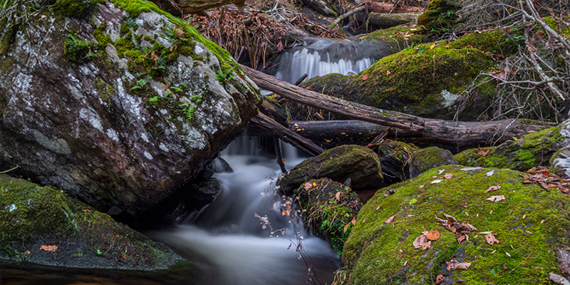
Apshawa Preserve Falls
4 Northwood Drive, West Milford | Passaic County
Nestled into the 576-acre Apshawa Preserve, these falls are created by natural cascades along Apshawa Brook, a tributary of the Pequannock River. The preserve, forested by oaks and sugar maples, is an idyllic destination for hikers, birders and nature enthusiasts. The falls are smaller than other waterfalls in New Jersey, but they are beautiful during spring or after a good rain.
Getting to the Falls
From the parking area, take the Blue Trail (1 mile) to the Green Trail toward Apshawa Brook. The Green Trail is a challenging hike with switchbacks and a few scrambles over roots and rocks. But the payoff? Scenic overlook spots to enjoy the natural falls and a 40-foot-tall manmade dam. If you prefer a beginner-friendly hike that’s mostly flat, stick to the BLUE trail, which will take you straight to the dam overlook (but doesn’t pass any natural falls).
Bridal Veil Falls
33 West Overlook Avenue, North Haledon | Passaic County
Did you know you can walk under a waterfall in New Jersey? Whether you're a nature enthusiast, a photography buff or simply looking for a serene escape, you’ll want to add Bridal Veil Falls to your list of must-sees in the Garden State. This cascade is located on the outskirts of the William Paterson University campus, within the scenic Preakness Range of the Watchung Mountains. Set in an abandoned sandstone quarry, this 40-foot waterfall dramatically plunges over the quarry’s cliff face after a good rain and turns into columns of icicles in winter. For an insider’s adventure, look for a footpath that will take you into a secluded cave behind the cascading water for a unique perspective that immerses you in nature’s beauty and power.
Getting to the Falls
Since parking is not permitted on Overlook Avenue (a residential street), your best bet is to make your way to the William Paterson University campus and leave your car in lot 6. From there, you’ll cross College Road to take the Red Trail for a nearly 1.5-mile hike to reach the old sandstone quarry the falls spill over.
Otter Hole Falls and Chikahoki Falls
Otter Hole Parking Lot, 575 Glenwild Avenue, Bloomingdale | Passaic County
Norvin Green State Forest is one of many parks in New Jersey with waterfalls. In fact, this park gives you two! Avid hikers looking for a good workout can choose from 21 official trails built from old logging roads, which offer views of Wanaque Reservoir and, on clear days, even the New York City skyline. But if you prefer a moderate 1.7-mile hike with a big payoff, Otter Hole and Chikahoki Falls may be just what you’ve been wishing for. Otter Hole Falls will greet you as the first scenic stop along the trail. It’s a lovely spot, perfect for a quick photo-op. However, don't spend too much time here — Chikahoki Falls (the main waterfall) is still about a mile up the trail, and it's truly worth the trek!
Getting to the Falls
This out-and-back hike is just under 2 miles but includes some steep hiking. Begin in the Otter Hole Parking lot and head north on the Highlands Trail, marked with teal diamonds. Just a tenth of a mile from your car, you’ll encounter Otter Hole. Continue north on the Highlands Trail to Posts Brook trail (white blazes), then take that to Chikahoki Falls. The trail descends almost 350 feet through a shaded forest canopy. It's recommended to wear waterproof footwear and a hat and bring sunscreen, water, and bug spray. The hike back up can be tiring, especially on hot days.
Greenbrook Falls
Greenbrook Road, Tenafly | Bergen County
Greenbrook Falls, standing at an impressive 250 feet, is the tallest waterfall in New Jersey. Situated in Greenbrook Sanctuary, this cascade is set amidst 165 acres of vibrant land in the Palisades Interstate Park, which spans from Tenafly to Alpine. The falls are fed by three streams that cascade dramatically down the cliff to meet the Hudson River below.
Getting to the Falls
In order to explore the area around Greenbrook Falls, you must be a member of the Palisades Nature Association to enter (and during sanctuary hours only). Greenbrook is located 0.8 miles north of E Clinton and 9W intersection. 4.7 miles north of the George Washington Bridge, off U.S. Route 9W. Heading north, take the Palisades Interstate Parkway North to Exit 1. Turn right at the stop sign of the exit ramp. At the first traffic light, turn right onto Route 9W North. At the 4th traffic light (East Clinton Ave.), the road narrows from two lanes to one. The entrance to Greenbrook is 0.8 miles north of East Clinton Ave. on the right side. From the south, take Exit 2 off the Palisades Interstate Parkway. Make a left onto Route 9W — headed south. You will go through 2 traffic lights and one blinking light. Pass the sign for Tamcrest Estates and watch for the large brown Greenbrook Sanctuary sign on the left at our entrance road.
Hemlock Falls
64 Cherry Lane, West Orange | Essex County
The 25-foot-high Hemlock Falls is buried deep in the woods at the South Mountain Reservation Complex. Though you’ll feel a world away from it all, you can also take in the NYC vistas from the eastern ridge portion of the trail. Hemlock Brook tumbles over a 25-foot rock wall, forming the falls before merging with the west branch of the Rahway River. The river then winds its way south, eventually filling Campbell’s Pond and Diamond Mill Pond before flowing out of the Reservation. Following a heavy rainfall, the falls are a spectacular sight, and in the winter, they frequently freeze into a breathtaking ice formation.
Getting to the Falls
The falls are easily accessible on foot. Park in the Tulip Springs parking area for a 1.6-mile hike with an elevation gain of 300 feet. This is a “lollipop” loop that follows the yellow-blazed Lenape Trail, loops around the red-dot Hemlock Falls Loop, and then retraces your steps back to the parking lot again via the Lenape Trail. This hike includes switchbacks, stone steps, a footbridge and views of the smaller Hobble Falls.
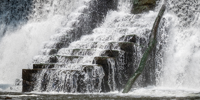
Paterson Great Falls
Overlook Park, 72 McBride Avenue Extension, Paterson | Passaic County
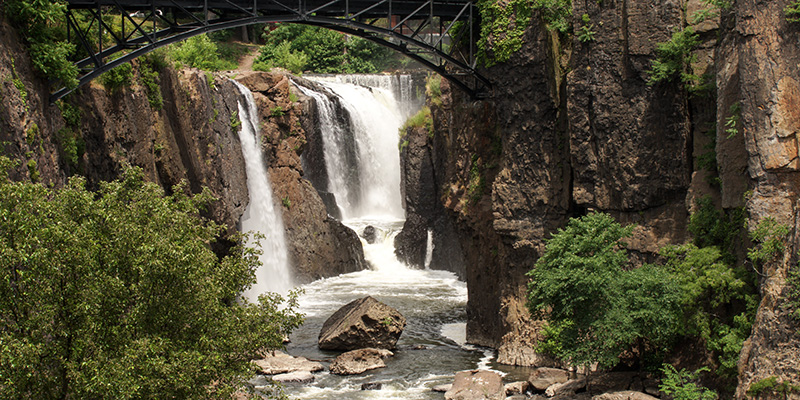 At Paterson Great Falls National Historical Park, the Passaic River plunges 77 feet over basalt cliffs. More than 2 billion gallons of water rush over the falls each day. In fact, it is the second-largest waterfall, by volume, east of the Mississippi River, behind only Niagara Falls. The park is a National Natural Landmark, with a rich history tied to several historical figures, the labor movement and early use of waterpower for industrial purposes.
Getting to the Falls
You can view the Paterson Great Falls from Overlook Park (parking permitted dawn to dusk only) and Mary Ellen Kramer Park (158 Maple Street). Most of the visitor services and facilities at Paterson Great Falls Park are wheelchair accessible with assistance. Walking tours are an excellent way to explore the park and learn about its history. These tours are free and among the park's most popular activities. Visitors can choose between a ranger-led tour or a self-guided one. The tours cover the history of Paterson, the Great Falls, and the events that led to the creation of this national historical park. Each tour lasts between 45 minutes to an hour and involves a 1-mile walk through the park.
Peanut Leap Cascade
State Line Lookout, 1 Alpine Approach Road, Alpine | Bergen County
With a town name of Alpine, you can expect the great heights required for a spectacular cascade — and Peanut Leap in Palisades Interstate Park does not disappoint. With 2,500 acres of wild Hudson River shoreline, uplands and cliffs, hikers have more than 30 miles of trails to discover, ranging from gentle riverside strolls to challenging rock scrambles.
Getting to the Falls
State Line Lookout has its own unnumbered exit from the Palisades Interstate Parkway in Alpine, New Jersey, about 2 miles north of Exit 2 (GPS: 40.989108, -73.906678). Here, you will find a wheelchair accessible scenic overlook, a refreshment stand and a gift shop. Ready to hike? Pick up a map and choose from a moderate-level 2.5-mile hike that takes about two hours to complete round trip (warning: children may find this hike difficult) or a very challenging 4-mile route that includes a difficult rock scramble and steep ascent and takes about three hours round trip (recommended for experienced hikers only).
Ramapo Falls
608 Ramapo Valley Road, Mahwah | Bergen County
At 4,000 acres, Ramapo Valley County Reservation is Bergen’s largest park area. Ramapo Falls offers a perfect mix of natural beauty and adventure. There are plenty of peaceful picnic areas, perfect for a relaxing day with family or enjoying the solitude of nature. Be sure to bring your camera, as the views are absolutely picture-perfect. For history buffs, there are old ruins and historical markers throughout the area, adding a fascinating historical element to your visit. Whether you’re a local or a visitor, Ramapo Falls is a must-see.
Getting to the Falls
From the paved parking area, find your way to the waterfalls via the aptly named Vista Loop, a 3.4 mile lollipop trail with an 850 foot elevation gain, multiple panoramic vistas, a reservoir, a grove of cactus and the waterfall. You will be following the yellow blazes for the entire hike, where it will climb steeply toward Hawk Rock and Cactus Ledge. To get directly to the waterfall, take the short side-trail, also marked with yellow blazes.
Boonton Falls
Grace Lord Park, 121 West Main Street, Boonton | Morris County
Tucked away in downtown Boonton, these falls are a short walk from the north end of Grace Lord Park. This little oasis is a perfect family-friendly destination for a day trip. You'll find a playground, gazebo and walking trails. Other sights include Washington Rock, a manmade dam and historical ruins of industrial sites like the New Jersey Iron Company that were powered by the falls long ago.
Getting to the Falls
The city park does not include a parking lot, so you will want to look for legal parking in the surrounding area. We recommend the street parking or the municipal lot on Plane Street. Once you enter Grace Lord Park from Main Street, pass the gazebo and head down the path into the woods. The route to the waterfall is short and easy.
Buttermilk Falls
Buttermilk Falls Trailhead, Mountain Road, Layton | Sussex County
 Towering 130 feet, Buttermilk Falls puts on quite a show and does not require a hike to see it! Visitors will find a small wheelchair-accessible lot adjacent to the falls, along with a viewing platform that allows you to get close to the cascades. Fun fact: The name “Buttermilk Falls” is believed to come from the frothy, white appearance of the water as it tumbles down the rocks, resembling buttermilk.
Getting to the Falls
To reach Buttermilk Falls, set your GPS to Buttermilk Falls Trailhead, Mountain Road, Layton, NJ. From Layton, follow NJ-615 North to Mountain Road. The final approach is a gravel road, which sometimes closes to vehicles in winter weather. You will want to check road conditions beforehand. For those wanting to hike, the 1.4-mile Buttermilk Falls Trail in the Delaware Water Gap National Recreation Area starts here with a steep stair climb to the top of Buttermilk Falls and the Appalachian National Scenic Trail for spectacular views of the valley below. This hike is rated moderate-difficult and is 1.4 miles, one-way.
Silver Spray Falls
Buttermilk Falls Trailhead, Mountain Road, Layton | Sussex County
The lesser-known of the Delaware Water Gap National Recreation Area's waterfalls, this cascade is sometimes called “Hidden Falls.” If you enjoy a challenge and relying on your wits, pursuing this cascade may be for you.
Getting to the Falls
From Buttermilk Falls Parking Lot, walk about a half mile north on Mountain Road to an unmarked trailhead. From the trailhead, it’s another quarter mile to Silver Spray Falls, but you need to cross the stream in order to find it. (They don’t call it “hidden” for nothing). Trekking poles are recommended. To Hidden Falls and back to Buttermilk, your total trip will be about 1.5 miles.
Dunnfield Creek Falls
2 Old Mine Road, Columbia | Warren County
 Discover this series of waterfalls at Worthington State Forest. A hike along Dunnfield Creek Trail unveils several small cascades along with a natural glacial lake rimmed with mature hemlock and mixed hardwood forests.
Getting to the Falls
You don’t need to hike the entire Dunnfield Creek Falls Trail (marked in light green blazes on the Worthington State Forest trail map) to see the falls. In under one mile, you’ll reach the first (and most scenic) of the cascades. The trailhead begins at the Pahaquarry Trail or the Appalachian Trail.
Laurel Falls
134 Old Mine Road, Columbia | Warren County
Before we leave Worthington State Forest, we want to let you in on an interesting fact. There is another rocky cascade that is just a hop, skip and a jump from the Douglas Trail parking area. Laurel Falls are part of a stream that flows from Sunfish Pond, and, like any waterfall, the water flow varies with recent rainfall, typically being strongest in the Spring.
Getting to the Falls
Park in the Douglas Trail parking lot on Old Mine Road and look for a casual, unmarked trail near the Douglas Trail sign. Follow the trail, and you’ll reach the lower parts of the cascade in no time. The trip out and back is just .3 miles. Insider info: The full Douglas Trail is 1.7 miles long and connects to the Appalachian Trail at a backpacker campsite.
Hacklebarney State Park Falls
119 Hacklebarney Road, Long Valley | Morris County
Experience the great outdoors at Hacklebarney State Park across its nine trails spanning a total of 5 miles in the northern portions of the 465-acre natural area. Within the park, the Rinehart and Trout Brooks flow into the Black River, creating picturesque small waterfalls visible from the higher trails. The park’s mix of upland and wetland habitats makes it a prime spot for birdwatching, particularly during migration season. The terrain here is rugged, so wear comfortable walking shoes!
Getting to the Falls
You have options. If you’re up for a moderate hike, take on Riverside Trail. You’ll find the trailhead on the left (east) side of Main Trail, approximately 75 yards from the parking lot. The Riverside Trail is 1.78 miles long and offers views of all three waterways in the park. Riverside Trail follows a single-track dirt path with natural obstacles and scenic vistas, waterfalls and pools, fishing access and picnic tables along the way. If you prefer to peep your waterfall without the hike, the Waterfall Trail is just 0.1 miles long and meets the Trout Brook, with views of the creek dropping over a series of large boulders with small pools and cascades. The Waterfall trail is 6 feet wide and surfaced with asphalt and gravel. You’ll find the trailhead on the Main Trail.
Schooley’s Mountain Falls
91 East Springtown Road, Washington Township | Morris County
One minute, kids are running ahead like fearless explorers — the next, they need to be carried. Do your kids have the energy, just not the endurance? Schooley’s Mountain County Park offers a kid-friendly trek (1 mile each way out and back) that follows a cascading stream to a beautiful waterfall, with plenty of boulders to climb along the way. Want to extend the adventure? A short detour leads to a scenic valley overlook, or you can turn the route into a loop for a slightly longer hike.
Getting to the Falls
From the entrance on East Springtown Road, turn into the park. To park near the trailhead, drive to the end of the road, then turn right and park in the parking lot. Look for the trailhead for the Falling Waters trail, marked the blue blazes.
Stepping Stone Falls
1 Coursen Road, Branchville | Sussex County
Tucked away in Stokes State Forest, Stepping Stone Falls is a peaceful retreat perfect for a scenic adventure. Whether you're looking for a refreshing pit stop, a serene photo op or a place to relax to the soothing sounds of rushing water, this hidden gem delivers. Witness fresh water spilling down a natural staircase and soak in the beauty of one of New Jersey’s quieter waterfall spots.
Getting to the Falls
Park in the parking area at the end of Kittle Road and look for the Stony Brook Trailhead. Stony Brook Trail is 2.8 miles (each way, out and back) and provides creek and waterfall views as it continues to Kittle Field, Stony Lake and Sunrise Mountain Road. Park officials say this trail is moderately steep and a good climb for those who wish for exercise.
Tillman Ravine Falls
1 Coursen Road, Branchville | Sussex County
 Another must-hike site in Stokes State Forest is the Tillman Ravine Trail, featuring classic cascades as well as “The Teacup,” a geological feature formed by swirling water, sand and rock. Tucked within the rugged beauty of Tillman Ravine Natural Area, “The Teacup” is a unique water formation along the Tillman Brook. This scenic spot sits along the Tillman Ravine Trail, a looping path that winds between ridges and a striking red shale and sandstone gorge. Towering hemlocks frame the rushing waters, creating a peaceful escape. Whether you're exploring the ravine’s dramatic landscape or simply pausing to admire the cascading water, "The Teacup" is a must-see natural wonder.
Getting to the Falls
You will find the trailhead for the Tillman Ravine Trail on the west side of the park, along Dimon Road. This 1.5-mile looping trail is rated a moderate hike.
Van Campen Glen Falls
Old Mine Road, Warren | Warren County
The Van Campen Glen Trail is a scenic gem tucked within the Delaware Water Gap National Recreation Area in northwestern New Jersey. This short but stunning hike follows Van Campen Brook through a lush ravine filled with mossy rocks, towering hemlocks and vibrant ferns. The trail is about 1.6 miles round trip and features a mix of boardwalks, wooden bridges and rocky terrain, making it a moderate but rewarding trek.
The highlight? Van Campen Glen Waterfall, a picturesque cascade that tumbles over layered rock formations into crystal-clear pools. It’s a peaceful spot where you can soak in the sounds of rushing water and the beauty of the surrounding forest.
Getting to the Falls
To reach the Van Campen Glen Trail in New Jersey's Delaware Water Gap National Recreation Area, head to the Upper Glen Parking Area on Old Mine Road, near the historic Millbrook Village. The trailhead is directly across the road from the parking area.
Kugler Falls
Kingwood Township| Hunterdon County
At just 10 feet tall and only appearing in wet seasons, this cascade nestled into The Kugler Woods Preserve is definitely not the largest or most powerful of the waterfalls on this list. However, the surrounding woodlands date back to the American Revolution and offer a peaceful setting. Here’s an insider’s tip: afternoon sunlight provides the best lighting for viewing the falls.
Getting to the Falls
A large parking lot is available on the west side of Route 29, just north of the trailhead, which is located on the east side of Route 29. From the parking lot, walk approximately 300 feet south along the wide shoulder of Route 29 to reach the trailhead, situated just beyond the guardrail. This trail is moderately strenuous due to a steep grade. Some sections are narrow with steep drop-offs.
Lake Solitude Waterfall
River Rd. (Rt. 639), High Bridge | Hunterdon
 With thousands and thousands of views on TikTok, this cascade can probably no longer be considered a “hidden gem.” The Lake Solitude Dam, originally constructed in 1858, has undergone various modifications over the years. The area played a pivotal role in the region's industrial development, with remnants of the Union Iron Works and other historical structures accessible via the local trails. While it isn’t a natural feature, we included this 40-foot-tall dam, so you can say you’ve been here too.
Getting to the Falls
The area features several trails suitable for both hikers and cyclists. The Columbia Trail is an 11-mile path that begins in High Bridge and extends through scenic forests, farms and parklands, closely following the South Branch of the Raritan River. The Taylor Steelworkers Historic Greenway is a 6.5-mile trail that meanders through High Bridge, passing historical sites like the TISCO Complex, a refurbished 100-year-old truss bridge, and the Union Iron Works ruins.
Not much of a hiker? You can take in the sights of Lake Solitude from the observation deck above the dam. You’ll find a small parking lot off River Road/Route 639 that can accommodate a handful of cars. Insider tip: Visitors have reported receiving parking tickets when parking outside designated areas, so it’s essential to adhere to posted parking regulations.
Lockatong High Falls
235 Kingwood Stockton Road, Stockton | Hunterdon
One of just a handful of cascades in Central Jersey, this off-the-beaten-path beauty is reached by a 1.8-mile (sometimes very muddy) hike. Located within the Lockatong Wildlife Management Area (WMA), this serene spot is an appealing destination for nature lovers.
Getting to the Falls
To reach the falls, drive along Route 519 (Kingwood Stockton Road) in Kingwood Township. Approximately 0.25 miles past the Kingwood Township Methodist Church, you'll find the entrance to the WMA on the left, marked by a sign. Turn onto the dirt driveway and continue to the circular dirt parking area. The hike to the falls is an out-and-back trail totaling approximately 1.8 miles. Generally considered easy, the trail is mostly level with a brief downhill section leading to the falls. However, the path can be muddy, especially after rainfall, and features roots and rocks, so appropriate footwear is recommended.
Tinton Falls
741 Tinton Avenue, Tinton Falls | Monmouth County
Many New Jersey visitors are surprised to find a substantial waterfall at the Jersey shore. This picturesque cascade is easily accessible near the Tinton Falls Municipal Center, where a scenic viewing area lets you soak in the natural beauty. Once a vital power source for a historic gristmill, the falls now offer a tranquil escape perfect for a quick nature break or a photo-worthy stop. With convenient parking and no hiking required, it’s an effortless way to experience one of New Jersey’s little-known natural wonders!
Getting to the Falls
Parking is available at the Tinton Falls Municipal Center. While there isn't a designated hiking trail leading directly to the waterfall (the land surrounding the area is private or restricted), the viewing area is easily accessible from the parking lot, making it convenient for visitors of all ages.
Tumble Falls
A series of waterfalls between Frenchtown and Stockton | Hunterdon County
Following Route 29 along a stretch of the official Delaware River Scenic Byway, you’ll find this duo of picturesque waterfalls. Located near the intersection of Route 29 and Tumble Falls Road, the uppermost waterfall is approximately 20 feet high. A lower waterfall, about 15 feet high, is located closer to Route 29. Both falls are visible from the road, especially during periods of higher water flow.
Getting to the Falls
With no designated parking area, observation point or deck, the Tumble Falls are the ultimate drive-by wonders.
Before you go chasing these waterfalls in NJ, make sure to check the official websites or social media pages of the park or public space for the latest operating hours, accessibility details and other need-to-know info. Can’t get enough of the great outdoors? Check out our full list of parks, forests and nature sites. Be sure to download our free Official Travel Guide and sign up for our e-newsletter for even more vacation inspiration.
Like to plan ahead? While many of NJ’s experiences take place annually, specifics on next year’s events will be updated as they become available.